Here are some photos and accounts from research done in Alaska while working for NOAA/ATDD and in conjunction with San Diego State University.
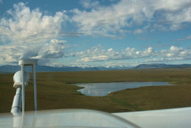
Alaskan Tundra from the cockpit of Long-EZ N3R: This photograph shows the view from the Long-EZ cockpit as the aircraft was headed south toward the Brooks Range from Prudhoe Bay, AK. Notice the lonely lake that appears next to the IRGA CO2/H2O sensor and the BAT (Best Aircraft Turbulence) gust probe protruding from the nose of the aircraft. This is typical of most scenery on the North Slope.. Desolate and beautiful!
The research done in Alaska was performed in cooperation with the Global Change Research Group of San Diego State University. NOAA/ATDD participated in field experiments between 1993 and 1998, based out of both Prudhoe Bay and Barrow. The main objective was to measure CO2/H2O fluxes over the tundra. Why?
The arctic tundra has been shown to hold about 1/3 of the world's carbon from the frozen biomass contained in the permafrost. Every summer following snowmelt, a thin layer of the permafrost thaws and becomes a mixture of dead and living plant matter. The dead and decaying plant matter releases CO2 into the atmosphere (it becomes a source), while the living plant matter takes in CO2 (it becomes a sink). There is a fine line between the amount of CO2 released into the atmosphere by the sources and that which is absorbed by the sinks. Early chamber measurements by SDSU showed the tundra to be a potential source of CO2 in the summer months. Click here to read more about the SDSU arctic research program.
Bear in mind these chamber measurements of CO2 were made at a few selected points in the tundra. If the results of these point measurements were extrapolated to the entire surface of the arctic tundra, a mind-boggling amount of CO2 gas could possibly be emitted to the atmosphere every summer. This could produce a catastrophic positive feedback to global warming, with potentially dire consequences. What was needed was a measurement of the spatial variability of the CO2 flux over the tundra. This is where the Long-EZ and SDSU Sky Arrow aircraft come in. Click here to read more about the Long-EZ program.

A rare thunderstorm approaching Prudhoe Bay, AK is shown in the picture to the left... This storm hit just minutes after I landed in Prudhoe Bay on the afternoon of June 15, 1996. It formed over the north slope of the Brooks Range and rolled all the way down the North Slope until it hit Prudhoe Bay.
Some interesting facts about the North Slope of Alaska in the summertime: Of course, it doesn't get dark in the summer between late May and early August above the Arctic Circle. Instead of moving across the top of the sky from East to West, the sun simply goes around the horizon from East to West, never actually setting, but never rising very high into the sky, either.
This makes flying at any time of the day or night rather interesting, because chances are that the sun will be right in your face depending on the airplane's heading and the time of day. For example, we flew missions out of Prudhoe Bay on a due North - due South line that extended typically from 10 miles over the Arctic Ocean to 100 miles south of Prudhoe Bay, in the foothills of the Brooks Range. We also flew the missions centered about solar noon and solar midnight, which meant that the sun was directly in your face either on the south-bound leg (at solar noon), or on the north-bound leg (at solar noon). The first time I flew the Long-EZ on this north-south transect at solar midnight it was fantastic... It was a clear and beautiful sky with no clouds and a very low sun angle to light the Brooks Range from behind the airplane on the trip south... I had fun flying the airplane about 50 feet above the ground (yes, 50 ft AGL) over the tundra and into the foothills. Up and down, following the rolling terrain. Then came the turnaround... As the plane turned into the sun, its altitude was below that of the highest hill in front of me (I was terrain huggin, after all). The sun then cast a shadow that made the terrain immediately in front of the plane black and extremely difficult to see. I ended up flying by looking out the side of the window to see if the terrain was rising or falling. Needless to say, the return trip was at a higher altitude than the trip down. As I did this more and more, though, I got better at keeping the altitude where it needed to be (50 ft AGL) throughout the transect.
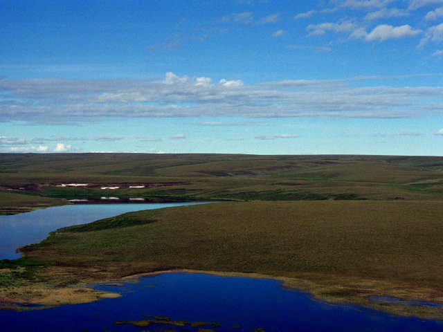
This is another nice arctic tundra shot.. It was taken from the Long-EZ cockpit somewhere between the Brooks Range and Prudhoe Bay, probably near solar noon. The airplane was northbound in the picture because the Brooks Range is not visible in the picture.
 Photography Notes: All images above were taken with a Nikon F
with Photomic light meter and a 50 mm Nikkor lens. The color
negatives were then scanned and .TIFF files created. The TIFF
files then converted to .JPG files for web distribution.
Photography Notes: All images above were taken with a Nikon F
with Photomic light meter and a 50 mm Nikkor lens. The color
negatives were then scanned and .TIFF files created. The TIFF
files then converted to .JPG files for web distribution.
ALL CONTENT ©EDWARD DUMAS. USE WITHOUT PERMISSION PROHIBITED!"